| Location |
| City: | | Gander, Newfoundland and Labrador, Canada |
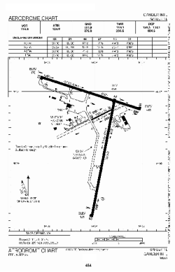
| Name: | Gander International Airport |
| ICAO / IATA: | CYQX / YQX |
Details |
| Type: | Airport (Airfield) |
| Use: | Public/Civil |
| Latitude: | 48°56'13"N (48.936944) |
| Longitude: | 54°34'05"W (-54.568055) |
| Elevation: | 496 ft (151 m) |
| Runways: | 2 |
| Longest: | 10200 ft (3109 m) |
Time |
| Timezone: | UTC+30:38 (DST+33:38) |
| Local Time: | |
Weather |
| METAR: | CYQX | 041400Z 23011KT 20SM FEW014 BKN130 OVC170 M09/M15 A3006 RMK SC1AC4AS3 SUN DMLY VISBL SLP194
|
| TAF: | CYQX | 041141Z 0412/0512 25015KT P6SM BKN180
FM041500 23012KT P6SM BKN140
FM041800 23012KT 3SM -SN OVC030 BECMG 0419/0421 19009KT
FM050300 23010KT P6SM SCT020 BECMG 0504/0506 30008KT
FM050600 30008KT P6SM SCT020 RMK NXT FCST BY 041800Z
|
Related Locations |
| Nearby: | |
| Farthest: | ALH: 11390 mi / 18331 km
Albany, WA, AU |
Find: |
|
Other Information |
Maps:
|
Sources:
|
|