| Location |
| City: | | Sudbury, Ontario, Canada |
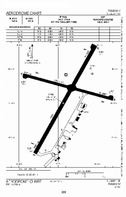
| Name: | Sudbury Airport (Greater Sudbury Airport) |
| ICAO / IATA: | CYSB / YSB |
Details |
| Type: | Airport (Airfield) |
| Use: | Public/Civil |
| Latitude: | 46°37'32"N (46.625556) |
| Longitude: | 80°47'52"W (-80.797777) |
| Elevation: | 1143 ft (348 m) |
| Runways: | 2 |
| Longest: | 6600 ft (2012 m) |
Time |
| Timezone: | UTC+29:08 (DST+32:08) |
| Local Time: | |
Weather |
| METAR: | CYSB | 041400Z 05012KT 10SM OVC007 M11/M12 A2991 RMK SF8 SLP156
|
| TAF: | CYSB | 041338Z 0414/0502 04012KT 5SM -SN -FZDZ BR OVC007 TEMPO 0414/0418 P6SM -SN OVC010 PROB30 0414/0418 6SM -PL BR
FM041800 06012G22KT 2SM -FZRA BR OVC005 TEMPO 0418/0422 6SM -FZRA BR OVC008
FM042200 08012G22KT 2SM -FZRA BR OVC003 TEMPO 0422/0424 6SM -FZRA BR OVC006
FM050000 13008KT 5SM -FZRA BR OVC005 TEMPO 0500/0502 6SM -FZRA BR OVC008 BECMG 0500/0502 27008KT RMK NXT FCST BY 042000Z
|
Related Locations |
| Nearby: | |
| Farthest: | YAUG: 11246 mi / 18098 km
Augusta [Augusta Airport], WA, AU |
Find: |
|
Other Information |
Maps:
|
Sources:
|
|