| Location |
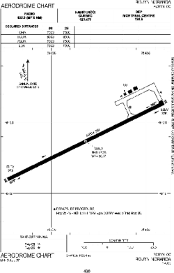
| City: | | Rouyn-Noranda, Québec, Canada |
| Name: | Rouyn-Noranda Airport |
| ICAO / IATA: | CYUY / YUY |
Details |
| Type: | Airport (Airfield) |
| Use: | Public/Civil |
| Latitude: | 48°12'22"N (48.206111) |
| Longitude: | 78°50'08"W (-78.835555) |
| Elevation: | 988 ft (301 m) |
| Runways: | 1 |
| Longest: | 7500 ft (2286 m) |
Time |
| Timezone: | UTC+29:08 (DST+32:08) |
| Local Time: | |
Weather |
| METAR: | CYUY | 041400Z 06008KT 15SM FEW010 FEW080 SCT180 BKN240 M15/M18 A3001 RMK CF1AC2AC1CI3 CF TR SLP192
|
| TAF: | CYUY | 041139Z 0412/0424 01006KT P6SM SCT020 BKN080 TEMPO 0412/0417 P6SM -SHSN BKN020 OVC080 BECMG 0414/0416 06006KT
FM041700 06006KT P6SM SCT020 BKN030 TEMPO 0417/0419 21/2SM -SN BKN020 OVC030
FM041900 08010KT 11/2SM -SN SCT008 OVC015
FM042100 09010KT 6SM -PL BKN008 OVC015 RMK NXT FCST BY 041800Z
|
Related Locations |
| Nearby: | |
| Farthest: | YAUG: 11235 mi / 18081 km
Augusta [Augusta Airport], WA, AU |
Find: |
|
Other Information |
Maps:
|
Sources:
|
|