| Location |
| City: | | La Ronge, Saskatchewan, Canada |
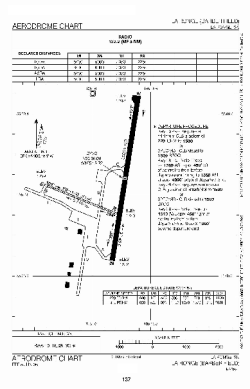
| Name: | Barber Field |
| ICAO / IATA: | CYVC / YVC |
Details |
| Type: | Airport (Airfield) |
| Use: | Public/Civil |
| Latitude: | 55°09'05"N (55.151389) |
| Longitude: | 105°16'01"W (-105.266943) |
| Elevation: | 1244 ft (379 m) |
| Runways: | 2 |
| Longest: | 5002 ft (1525 m) |
Time |
| Timezone: | UTC+28:08 (DST+30:08) |
| Local Time: | |
Weather |
| METAR: | CYVC | 041400Z 03002KT 15SM FEW150 SCT250 M38/M41 A3040 RMK AC2CI1 SLP357
|
| TAF: | CYVC | 041238Z 0413/0501 VRB03KT P6SM FEW012 SCT160 SCT220 TEMPO 0413/0418 4SM IC
FM041800 28005KT P6SM SCT012 BKN100 BKN220 TEMPO 0418/0501 4SM -SN BKN012 RMK NXT FCST BY 041900Z
|
Related Locations |
| Nearby: | |
| Farthest: | YCSK: 11018 mi / 17732 km
Casey Station [Casey Station Skiway], Wilkes Land, AQ |
Find: |
|
Other Information |
Maps:
|
Sources:
|
|