| Location |
| City: | | Val-d'Or, Québec, Canada |
| Name: | Val-d'Or Airport |
| ICAO / IATA: | CYVO / YVO |
Details |
| Type: | Airport (Airfield) |
| Use: | Public/Civil |
| Latitude: | 48°03'12"N (48.053333) |
| Longitude: | 77°46'58"W (-77.782777) |
| Elevation: | 1105 ft (337 m) |
| Runways: | 1 |
| Longest: | 10000 ft (3048 m) |
Time |
| Timezone: | UTC+29:08 (DST+32:08) |
| Local Time: | |
Weather |
| METAR: | CYVO | 041400Z 01006KT 15SM FEW014 SCT180 BKN260 M14/M16 A2999 RMK SF2AC2CI2 SLP190
|
| TAF: | CYVO | 041139Z 0412/0424 36006KT P6SM SCT015 OVC030 TEMPO 0412/0418 P6SM -SHSN BKN015 OVC030 BECMG 0413/0415 04010KT
FM041800 06010KT 5SM -SN BKN020 OVC030
FM042000 07012KT 21/2SM -SN OVC020
FM042200 08012KT 6SM -PL BKN008 OVC015 RMK NXT FCST BY 041800Z
|
Related Locations |
| Nearby: | |
| Farthest: | YAUG: 11274 mi / 18144 km
Augusta [Augusta Airport], WA, AU |
Find: |
|
Other Information |
Maps:
|
Sources:
|
|
|
|
Airport Diagram
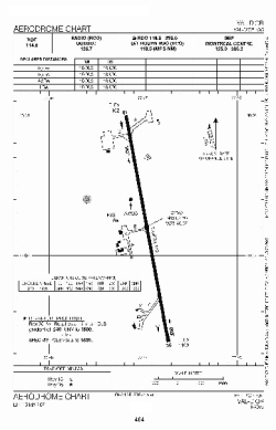
Airport diagram PDF from NAV Canada
|
