world map with YVQ marked

YVQ - Airport

This information may not be accurate or current and is not valid for navigation or flight planning. No warranty of fitness for any purpose is made or implied.

flag of Northwest Territoriesflag of Canada

Donate via PayPal

Additional information is available on the NEW Great Circle Mapper

Location
City:  Norman Wells, Northwest Territories, Canada
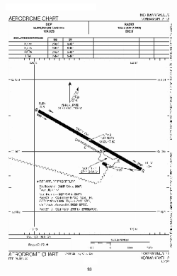
Name:Norman Wells Airport
ICAO / IATA:CYVQ / YVQ

Details
Type:Airport (Airfield)
Use:Public/Civil
Latitude:65°16'53"N (65.281389)
Longitude:126°47'55"W (-126.798610)
Elevation:237 ft (72 m)
Runways:1
Longest:5998 ft (1828 m)

Weather
METAR:CYVQ  041400Z 11007KT 30SM BKN150 BKN210 M27/M31 A3010 RMK AC5CI1 SLP207
TAF:CYVQ  041138Z 0412/0424 11008KT P6SM FEW160
FM041500 12010KT P6SM OVC100
FM042100 12010KT P6SM -SN OVC060 TEMPO 0421/0424 4SM -SN SCT020 OVC030 RMK NXT FCST BY 041800Z

Related Locations
Nearby:
Farthest:FAME: 11035 mi / 17759 km
Marion Island, Prince Edward Islands, WC, ZA

Find:

   beyond  
but within

Other Information
Maps:
Sources:


Airport Diagram

Airport diagram for YVQ

Airport diagram PDF from NAV Canada


Great Circle Mapper   Great Circle Mapper
Great Circle Mapper FAQ   Great Circle Mapper FAQ
  Karl's Home Page
KLSē   KLSē Home
   GC on Facebook
Airlines of the World   Airlines of the World
Donate via PayPal


Copyright © 2004-2023, Karl L. Swartz. All rights reserved.
All trademarks mentioned herein belong to their respective owners.

Please see credits for attribution and copyright information.

Karl Swartz <karl@kls2.com>
  Powered by FreeBSD
Valid HTML 4.01!
Labeled with ICRA
hCard Microformat
Geo Microformat