| Location |
| City: | | Wiarton, Ontario, Canada |
| Name: | Wiarton Airport |
| ICAO / IATA: | CYVV / YVV |
Details |
| Type: | Airport (Airfield) |
| Use: | Public/Civil |
| Latitude: | 44°44'39"N (44.744167) |
| Longitude: | 81°06'31"W (-81.108610) |
| Elevation: | 728 ft (222 m) |
| Runways: | 2 |
| Longest: | 5033 ft (1534 m) |
Time |
| Timezone: | UTC+29:08 (DST+32:08) |
| Local Time: | |
Weather |
| METAR: | CYVV | 041420Z 11006KT 050V110 1/2SM -DZ FG VV005 02/02 A2985 RMK FG8 SLP116
|
| TAF: | CYVV | 041338Z 0414/0424 VRB03KT 1/4SM -RA -DZ FG VV002 TEMPO 0414/0416 2SM BR SCT002 OVC004 BECMG 0414/0416 18008KT
FM041600 18008KT 6SM BR SCT004 OVC020 TEMPO 0416/0417 3SM -DZ BR BKN004
FM041700 18010G20KT P6SM SCT020 BKN040 TEMPO 0417/0419 5SM -DZ BR BKN020
FM041900 19015G25KT 6SM -RA BR BKN020 OVC030 TEMPO 0419/0422 5SM -RA BR
FM042200 20018G28KT 1SM -RA BR OVC005 RMK NXT FCST BY 042000Z
|
Related Locations |
| Nearby: | |
| Farthest: | YAUG: 11313 mi / 18207 km
Augusta [Augusta Airport], WA, AU |
Find: |
|
Other Information |
Maps:
|
Sources:
|
|
|
|
Airport Diagram
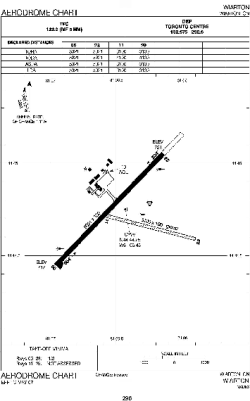
Airport diagram PDF from NAV Canada
|
