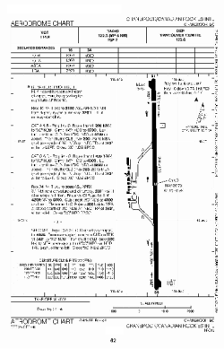
world map with YXC marked

YXC - Airport

This information may not be accurate or current and is not valid for navigation or flight planning. No warranty of fitness for any purpose is made or implied.

flag of British Columbiaflag of Canada

Donate via PayPal

Additional information is available on the NEW Great Circle Mapper

Location
City:  Cranbrook, British Columbia, Canada
ICAO / IATA:CYXC / YXC

Details
Type:Airport (Airfield)
Use:Public/Civil
Latitude:49°36'44"N (49.612222)
Longitude:115°46'55"W (-115.781943)
Datum:WGS 1984
Elevation:3084 ft (940 m)
Runways:1
Longest:8000 × 150 ft (2438 × 45.5 m)

Time
Timezone:UTC-8 (DST-7)
Local Time:

Weather
METAR:CYXC  101900Z 01002KT 5SM -SN FEW009 BKN030 M01/M04 A3022 RMK ST1SC7 VIS NW-NE 20 SLP273
TAF:CYXC  101838Z 1019/1107 VRB03KT P6SM OVC030 TEMPO 1019/1021 4SM -SN SCT008 OVC020 PROB30 1019/1021 2SM -SN BKN008
FM102100 16005KT P6SM BKN050 TEMPO 1021/1107 5SM -SN SCT020 BKN040 RMK NXT FCST BY 110100Z

Related Locations
Nearby:
Farthest:FAME: 11214 mi / 18047 km
Marion Island, Prince Edward Islands, ZA

Find:

   beyond  
but within

Other Information
Maps:
Links:
Sources:


Airport Diagram

Airport diagram for YXC

Airport diagram PDF from NAV Canada


Great Circle Mapper   Great Circle Mapper
Great Circle Mapper FAQ   Great Circle Mapper FAQ
  Karl's Home Page
KLSē   KLSē Home
   GC on Facebook
Airlines of the World   Airlines of the World
Donate via PayPal


Copyright © 2004-2012, Karl L. Swartz. All rights reserved.
All trademarks mentioned herein belong to their respective owners.

Please see credits for attribution and copyright information.

Karl Swartz <karl@kls2.com>
  Powered by FreeBSD
Valid HTML 4.01!
Labeled with ICRA
hCard Microformat
Geo Microformat