| Location |
| City: | | Sioux Lookout, Ontario, Canada |
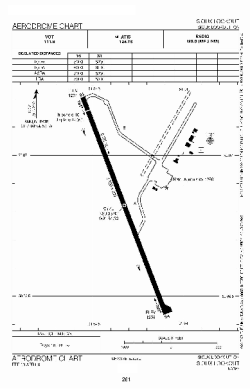
| Name: | Sioux Lookout Airport |
| ICAO / IATA: | CYXL / YXL |
Details |
| Type: | Airport (Airfield) |
| Use: | Public/Civil |
| Latitude: | 50°06'51"N (50.114167) |
| Longitude: | 91°54'20"W (-91.905555) |
| Elevation: | 1257 ft (383 m) |
| Runways: | 1 |
| Longest: | 5300 ft (1615 m) |
Time |
| Timezone: | UTC+29:08 (DST+32:08) |
| Local Time: | |
Weather |
| METAR: | CYXL | 041400Z 04003KT 1 1/4SM -SN VV008 M22/M24 A3000 RMK SN8 SLP205
|
| TAF: | CYXL | 041338Z 0414/0502 05008KT 3/4SM -SN VV007 TEMPO 0414/0418 3SM -SN OVC015
FM041800 01008KT 11/2SM -SN OVC012 TEMPO 0418/0424 5SM -SN OVC025
FM050000 01008KT P6SM BKN025 OVC080 TEMPO 0500/0502 BKN020 OVC080 RMK NXT FCST BY 042000Z
|
Related Locations |
| Nearby: | |
| Farthest: | YCSK: 11056 mi / 17793 km
Casey Station [Casey Station Skiway], Wilkes Land, AQ |
Find: |
|
Other Information |
Maps:
|
Sources:
|
|