| Location |
| City: | | Prince George, British Columbia, Canada |
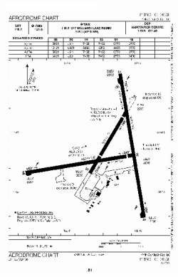
| Name: | Prince George Airport |
| ICAO / IATA: | CYXS / YXS |
Details |
| Type: | Airport (Airfield) |
| Use: | Public/Civil |
| Latitude: | 53°53'03"N (53.884167) |
| Longitude: | 122°40'39"W (-122.677499) |
| Elevation: | 2266 ft (691 m) |
| Runways: | 3 |
| Longest: | 11450 ft (3490 m) |
Time |
| Timezone: | UTC+26:08 (DST+29:08) |
| Local Time: | |
Weather |
| METAR: | CYXS | 041400Z AUTO VRB02KT 9SM CLR M35/M38 A3004 RMK SLP269
|
| TAF: | CYXS | 041238Z 0413/0501 VRB03KT P6SM SKC TEMPO 0413/0419 3SM IC PROB30 0413/0419 1SM IC RMK FCST BASED ON AUTO OBS. NXT FCST BY 041900Z
|
Related Locations |
| Nearby: | |
| Farthest: | FAME: 11454 mi / 18433 km
Marion Island, Prince Edward Islands, WC, ZA |
Find: |
|
Other Information |
Maps:
|
Links:
|
Sources:
|
|