| Location |
| City: | | Sandspit, British Columbia, Canada |
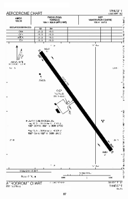
| Name: | Sandspit Airport |
| ICAO / IATA: | CYZP / YZP |
Details |
| Type: | Airport (Airfield) |
| Use: | Public/Civil |
| Latitude: | 53°15'15"N (53.254167) |
| Longitude: | 131°48'50"W (-131.813888) |
| Elevation: | 21 ft (6 m) |
| Runways: | 1 |
| Longest: | 5112 ft (1558 m) |
Time |
| Timezone: | UTC+26:08 (DST+29:08) |
| Local Time: | |
Weather |
| METAR: | CYZP | 041400Z AUTO 33014G19KT 9SM CLR M02/M10 A3011 RMK ICG SLP198
|
| TAF: | CYZP | 041238Z 0413/0501 33015KT P6SM SKC
FM041800 33015KT P6SM BKN050
FM042000 33010KT P6SM SCT015 BKN030 TEMPO 0420/0501 P6SM -RA BKN015 OVC030 RMK FCST BASED ON AUTO OBS. NXT FCST BY 041900Z
|
Related Locations |
| Nearby: | |
| Farthest: | FAME: 11799 mi / 18988 km
Marion Island, Prince Edward Islands, WC, ZA |
Find: |
|
Other Information |
Maps:
|
Sources:
|
|