| Location |
| City: | | Whitecourt, Alberta, Canada |
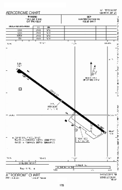
| Name: | Whitecourt Airport |
| ICAO / IATA: | CYZU / YZU |
Details |
| Type: | Airport (Airfield) |
| Use: | Public/Civil |
| Latitude: | 54°08'38"N (54.143889) |
| Longitude: | 115°47'12"W (-115.786666) |
| Elevation: | 2567 ft (782 m) |
| Runways: | 1 |
| Longest: | 5797 ft (1767 m) |
Time |
| Timezone: | UTC+27:08 (DST+30:08) |
| Local Time: | |
Weather |
| METAR: | CYZU | 041400Z 00000KT 10SM -SN FEW035 SCT100 M30/M33 A3016 RMK SC2AC2 SLP312
|
| TAF: | CYZU | 041410Z 0414/0423 VRB03KT P6SM FEW040 SCT100 TEMPO 0414/0420 5SM -SN IC BKN040
FM042000 10006KT P6SM FEW040 RMK NXT FCST BY 041900Z
|
Related Locations |
| Nearby: | |
| Farthest: | FAME: 11181 mi / 17993 km
Marion Island, Prince Edward Islands, WC, ZA |
Find: |
|
Other Information |
Maps:
|
Sources:
|
|