| Location |
| City: | | Faro, Yukon, Canada |
| Name: | Faro Airport |
| ICAO / IATA: | CZFA / ZFA |
Details |
| Type: | Airport (Airfield) |
| Use: | Public/Civil |
| Latitude: | 62°12'25"N (62.206944) |
| Longitude: | 133°22'24"W (-133.373332) |
| Elevation: | 2350 ft (716 m) |
| Runways: | 1 |
| Longest: | 3997 ft (1218 m) |
Weather |
| METAR: | CZFA | 032300Z 14007KT 30SM FEW200 SCT220 BKN240 M31/M36 A3023 RMK CS2CC2CI3 CLIMAT -31.3/-41.0/0.0 LAST STFD OBS/NXT 041500Z SLP358
|
| TAF: | CZFA | 031738Z 0318/0323 13006KT P6SM BKN200 TEMPO 0318/0321 3SM IC BR
FM032100 11005KT P6SM BKN150 TEMPO 0321/0323 3SM IC BR RMK NXT FCST WILL BE ISSUED AT 041645Z
|
Related Locations |
| Nearby: | |
| Farthest: | FAME: 11315 mi / 18210 km
Marion Island, Prince Edward Islands, WC, ZA |
Find: |
|
Other Information |
Maps:
|
Sources:
|
|
|
|
Airport Diagram
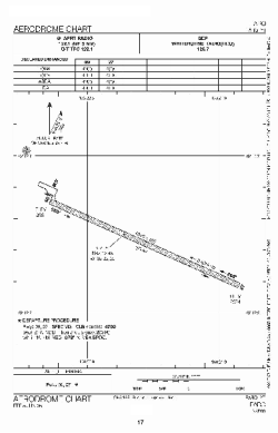
Airport diagram PDF from NAV Canada
|
