| Location |
| City: | | Masset, Haida Gwaii (Queen Charlotte Islands), British Columbia, Canada |
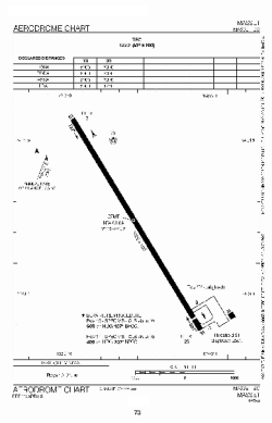
| Name: | Masset Airport |
| ICAO / IATA: | CZMT / ZMT |
Details |
| Type: | Airport (Airfield) |
| Use: | Public/Civil |
| Latitude: | 54°01'38"N (54.027222) |
| Longitude: | 132°07'30"W (-132.124999) |
| Elevation: | 19 ft (6 m) |
| Runways: | 1 |
| Longest: | 4924 ft (1501 m) |
Time |
| Timezone: | UTC+26:08 (DST+29:08) |
| Local Time: | |
Weather |
| METAR: | CZMT | 040200Z VRB04G18KT 15SM FEW040 M02/M14 A3012 RMK CU1 LAST STFD OBS/NEXT 041500 UTC SLP202
|
| TAF: | CZMT | 031838Z 0319/0402 02010G30KT P6SM BKN050 BECMG 0319/0321 FEW050 RMK NXT FCST WILL BE ISSUED AT 041615Z
|
Related Locations |
| Nearby: | |
| Farthest: | FAME: 11772 mi / 18945 km
Marion Island, Prince Edward Islands, WC, ZA |
Find: |
|
Other Information |
Maps:
|
Sources:
|
|