| Location |
| City: | | Belfast, County Antrim, Northern Ireland, United Kingdom |
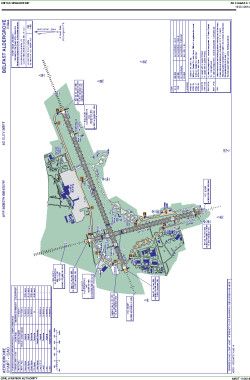
| Name: | Aldergrove International Airport |
| ICAO / IATA: | EGAA / BFS |
Details |
| Type: | Airport (Aerodrome, Airfield) |
| Use: | Public/Civil |
| Latitude: | 54°39'27"N (54.657500) |
| Longitude: | 6°12'57"W (-6.215832) |
| Elevation: | 268 ft (82 m) |
| Runways: | 2 |
| Longest: | 9121 × 148 ft (2780 × 45 m) |
Time |
| Timezone: | UTC+0 (DST+3) |
| Local Time: | |
Weather |
| METAR: | EGAA | 041350Z 27010KT 9999 FEW029 SCT035 08/03 Q1015
|
| TAF: | EGAA | 041056Z 0412/0512 24007KT 9999 SCT020 PROB30 0422/0506 7000 BECMG 0508/0511 14016G26KT BKN012 PROB40 TEMPO 0509/0512 8000 RA BKN008
|
Related Locations |
| Nearby: | |
| Farthest: | SZS: 11841 mi / 19055 km
Ryan's Creek, Stewart Island, STL, NZ |
Find: |
|
Other Information |
Maps:
|
Sources:
|
|