| Location |
| City: | | Budapest, Budapest, Hungary |
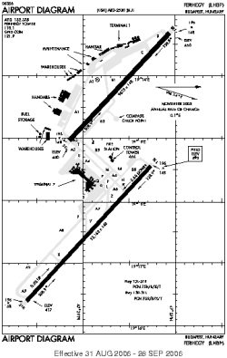
| Name: | Budapest International (Budapest Ferenc Liszt International, Ferihegy International) |
| ICAO / IATA: | LHBP / BUD |
Details |
| Type: | Airport (Aerodrome, Airfield) |
| Use: | Public/Civil |
| Latitude: | 47°26'13"N (47.436933) |
| Longitude: | 19°15'20"E (19.255592) |
| Datum: | WGS 1984 |
| Elevation: | 495 ft (151 m) |
| Runways: | 2 |
| Longest: | 12162 × 195 ft (3707 × 59.5 m) |
Time |
| Timezone: | UTC+1 (DST+4) |
| Local Time: | |
Weather |
| METAR: | LHBP | 041400Z 31011KT 9999 BKN025 05/01 Q1027 NOSIG
|
| TAF: | LHBP | 041115Z 0412/0512 30014G24KT 9999 SCT028 SCT220 BECMG 0412/0414 32009KT BECMG 0414/0416 32004KT BKN018 BECMG 0418/0420 CAVOK TEMPO 0501/0507 FZMIFG BECMG 0510/0512 -RA BKN043 OVC060
|
Related Locations |
| Nearby: | |
| Farthest: | CHT: 11639 mi / 18731 km
Waitangi [Tuuta], CIT, NZ |
Find: |
|
Other Information |
Maps:
|
Links:
|
Sources:
|
|