| Location |
| City: | | Okinawa, Ryukyu Island, Okinawa, Japan |
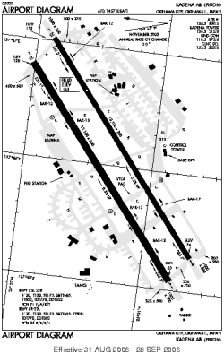
| Name: | Kadena AB |
| ICAO / IATA: | RODN / DNA |
Details |
| Type: | Airport (Aerodrome, Airfield) |
| Use: | Military |
| Latitude: | 26°21'20"N (26.355612) |
| Longitude: | 127°46'03"E (127.767633) |
| Datum: | WGS 1984 |
| Elevation: | 143 ft (44 m) |
| Runways: | 2 |
| Longest: | 12100 × 300 ft (3688 × 91.5 m) |
Time |
| Timezone: | UTC+9 (DST+11) |
| Local Time: | |
Weather |
| METAR: | RODN | 041356Z AUTO 07009KT 10SM OVC033 18/16 A3011 RMK AO2 SLP203 T01770160 $
|
| TAF: | RODN | 040800Z 0408/0514 05012KT 9999 VCSH BKN019 QNH3006INS TEMPO 0409/0412 8000 -SHRA BKN010 BECMG 0423/0424 09010G15KT 8000 -SHRA BKN010 QNH2997INS TX24/0506Z TN17/0421Z
|
Related Locations |
| Nearby: | |
| Farthest: | SSPS: 12419 mi / 19986 km
Palmas, PR, BR |
Find: |
|
Other Information |
Maps:
|
Links:
|
Sources:
|
|