| Location |
| City: | | Anglesey, Anglesey, Wales, United Kingdom |
| Near (Alt.): | Holyhead |
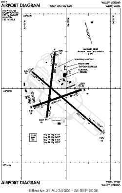
| Name: | Anglesey Airport/RAF Valley (Maes Awyr Môn) |
| ICAO / IATA: | EGOV / VLY |
Details |
| Type: | Airport (Aerodrome, Airfield) |
| Use: | Public/Civil, Military |
| Latitude: | 53°14'53"N (53.248097) |
| Longitude: | 4°32'07"W (-4.535338) |
| Datum: | WGS 1984 |
| Elevation: | 37 ft (11 m) |
| Runways: | 3 |
| Longest: | 7513 × 151 ft (2290 × 46 m) |
Time |
| Timezone: | UTC+0 (DST+3) |
| Local Time: | |
Weather |
| METAR: | EGOV | 041350Z 28011KT 9999 FEW017 BKN200 09/05 Q1016 BLU NOSIG
|
| TAF: | EGOV | (expired) |
Related Locations |
| Nearby: | |
| Farthest: | SZS: 11886 mi / 19129 km
Ryan's Creek, Stewart Island, STL, NZ |
Find: |
|
Other Information |
Maps:
|
Links:
|
Sources:
|
|