| Location |
| City: | | Geneva, Genève, Switzerland |
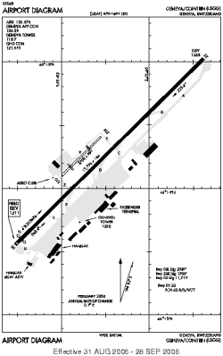
| Name: | Geneve-Cointrin |
| ICAO / IATA: | LSGG / GVA |
Details |
| Type: | Airport (Aerodrome, Airfield) |
| Use: | Public/Civil |
| Latitude: | 46°14'17"N (46.238064) |
| Longitude: | 6°06'32"E (6.108950) |
| Datum: | WGS 1984 |
| Elevation: | 1411 ft (430 m) |
| Runways: | 2 |
| Longest: | 12795 × 164 ft (3900 × 50 m) |
Time |
| Timezone: | UTC+1 (DST+4) |
| Local Time: | |
Weather |
| METAR: | LSGG | 041350Z 06004KT 340V140 9999 FEW025 SCT300 03/M03 Q1026 NOSIG
|
| TAF: | LSGG | 041125Z 0412/0518 06005KT 9999 FEW020 TX04/0415Z TNM01/0506Z TX05/0515Z BECMG 0412/0414 CAVOK
|
Related Locations |
| Nearby: | |
| Farthest: | CHT: 12224 mi / 19672 km
Waitangi [Tuuta], CIT, NZ |
Find: |
|
Other Information |
Maps:
|
Links:
|
Sources:
|
|