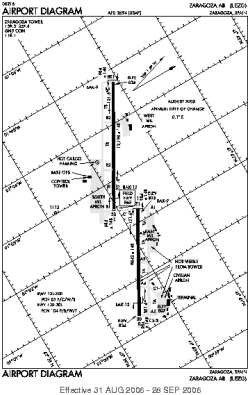
world map with LEZG marked

LEZG - Airport

This information may not be accurate or current and is not valid for navigation or flight planning. No warranty of fitness for any purpose is made or implied.

flag of Aragónflag of Spain

Donate via PayPal

Additional information is available on the NEW Great Circle Mapper

Location
City:  Zaragoza, Aragón, Spain
Name:Zaragoza Airport (Zaragoza AB)
ICAO / IATA:LEZG / ZAZ

Details
Type:Airport (Aerodrome, Airfield)
Use:Public/Civil, Military
Latitude:41°39'58"N (41.666242)
Longitude:1°02'30"W (-1.041552)
Datum:WGS 1984
Elevation:863 ft (263 m)
Runways:2
Longest:12198 × 148 ft (3718 × 45 m)

Time
Timezone:UTC+1 (DST+4)
Local Time:

Weather
METAR:LEZG  041400Z 30023KT CAVOK 13/M02 Q1025
TAF:LEZG  041100Z 0412/0512 29013KT 9999 FEW040 TX14/0414Z TN06/0506Z TEMPO 0412/0418 30015G25KT BECMG 0418/0420 27008KT

Related Locations
Nearby:
Farthest:NZPO: 12283 mi / 19767 km
Porangahau, HKB, NZ

Find:

   beyond  
but within

Other Information
Maps:
Links:
Sources:


Airport Diagram

Airport diagram for LEZG

Airport diagram (OBSOLETE) from NGA


Great Circle Mapper   Great Circle Mapper
Great Circle Mapper FAQ   Great Circle Mapper FAQ
  Karl's Home Page
KLS˛   KLS˛ Home
   GC on Facebook
Airlines of the World   Airlines of the World
Donate via PayPal


Copyright © 2004-2023, Karl L. Swartz. All rights reserved.
All trademarks mentioned herein belong to their respective owners.

Please see credits for attribution and copyright information.

Karl Swartz <karl@kls2.com>
  Powered by FreeBSD
Valid HTML 4.01!
Labeled with ICRA
hCard Microformat
Geo Microformat