| Location |
| City: | | Murmansk, Murmanskaya, Russian Federation (Russia) |
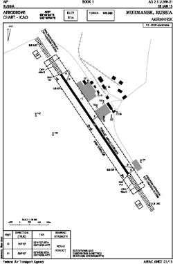
| Name: | Murmansk Airport |
| ICAO / IATA: | ULMM / MMK |
Details |
| Type: | Airport (Aerodrome, Airfield) |
| Use: | Public/Civil |
| Latitude: | 68°46'54"N (68.781667) |
| Longitude: | 32°45'04"E (32.751111) |
| Elevation: | 266 ft (81 m) |
| Runways: | 1 |
| Longest: | 8202 × 138 ft (2500 × 42 m) |
Time |
| Timezone: | UTC+3 (DST+4) |
Weather |
| METAR: | ULMM | 041400Z 17001MPS CAVOK M32/M37 Q1026 R31/450245 NOSIG RMK QFE762
|
| TAF: | ULMM | 041050Z 0412/0512 12003G08MPS 9999 SCT013 TXM22/0421Z TNM30/0412Z TEMPO 0412/0418 15003G08MPS 5000 -SHSN BR FEW006 BKN013CB BECMG 0418/0420 3100 -SHSN BR BKN011CB TEMPO 0420/0512 15003MPS 1000 -SHSN BR BKN004 BKN011CB
|
Related Locations |
| Nearby: | |
| Farthest: | NZWD: 11369 mi / 18296 km
McMurdo Station [Williams Field], Ross Island, AQ |
Find: |
|
Other Information |
Maps:
|
Links:
|
Sources:
|
|