| Location |
| City: | | Manila, Philippines |
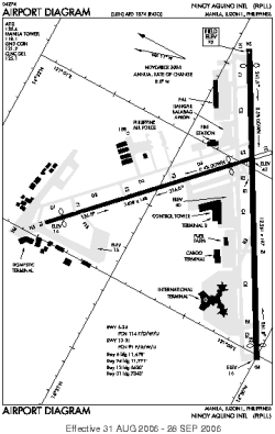
| Name: | Ninoy Aquino International Airport |
| ICAO / IATA: | RPLL / MNL |
Details |
| Type: | Airport (Aerodrome, Airfield) |
| Use: | Public/Civil, Military |
| Latitude: | 14°30'31"N (14.508647) |
| Longitude: | 121°01'10"E (121.019581) |
| Datum: | WGS 1984 |
| Elevation: | 75 ft (23 m) |
| Runways: | 2 |
| Longest: | 12261 × 197 ft (3737 × 60 m) |
Time |
| Timezone: | UTC+8 (DST+10) |
| Local Time: | |
Weather |
| METAR: | RPLL | 041400Z 10008KT 9999 FEW025 25/20 Q1016 NOSIG RMK A3000
|
| TAF: | RPLL | 041100Z 0412/0518 10008KT 9999 FEW025 TX31/0506Z TN23/0422Z TEMPO 0415/0421 06005KT TEMPO 0504/0510 11015KT FEW023 SCT100
|
Related Locations |
| Nearby: | |
| Farthest: | SSVW: 12411 mi / 19973 km
Conquista D`Oeste [Fazenda Galera], MT, BR |
Find: |
|
Other Information |
Maps:
|
Sources:
|
|