| Location |
| City: | | Petropavlovsk-Kamchatsky, Kamchatskiy, Russian Federation (Russia) |
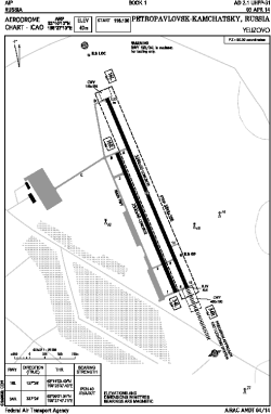
| Name: | Yelizovo Airport |
| ICAO / IATA: | UHPP / PKC |
Details |
| Type: | Airport (Aerodrome, Airfield) |
| Use: | Public/Civil |
| Latitude: | 53°10'13"N (53.170278) |
| Longitude: | 158°27'13"E (158.453611) |
| Elevation: | 131 ft (40 m) |
| Runways: | 1 |
| Longest: | 11148 × 197 ft (3398 × 60 m) |
Time |
| Timezone: | UTC+12 (DST+13) |
Weather |
| METAR: | UHPP | 041400Z 02003MPS 9999 NSC M12/M16 Q0995 R34L/810370 NOSIG RMK QFE743/0990
|
| TAF: | UHPP | 041353Z 0415/0521 01003G12MPS 9999 NSC
FM042300 32003G12MPS 9999 BKN020CB OVC050 TEMPO 0423/0521 08003G12MPS 1000 SHSN BR VV003
|
Related Locations |
| Nearby: | |
| Farthest: | FAGE: 11391 mi / 18332 km
Gough Island (Conçalo Álvares), TA, SH |
Find: |
|
Other Information |
Maps:
|
Links:
|
Sources:
|
|