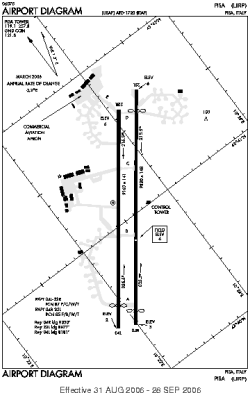
world map with PSA marked

PSA - Airport

This information may not be accurate or current and is not valid for navigation or flight planning. No warranty of fitness for any purpose is made or implied.

flag of Italy

Donate via PayPal

Additional information is available on the NEW Great Circle Mapper

Location
City:  Pisa, Tuscany, Italy
Near (Alt.):San Giusto
Name:Galileo Galilei International Airport
ICAO / IATA:LIRP / PSA

Details
Type:Airport (Aerodrome, Airfield)
Use:Public/Civil, Military
Latitude:43°41'02"N (43.683917)
Longitude:10°23'34"E (10.392750)
Datum:WGS 1984
Elevation:6 ft (2 m)
Runways:2
Longest:9820 × 148 ft (2993 × 45 m)

Time
Timezone:UTC+1 (DST+2)
Local Time:

Weather
METAR:LIRP  120315Z 12011KT 9999 SCT040 BKN060 M01/M08 Q1017 5401//55 NOSIG
TAF:LIRP  112300Z 1200/1224 12004KT 9999 SCT020 BKN060 PROB30 TEMPO 1203/1208 5000 -SN BR SCT010 BKN030 BECMG 1210/1213 09012KT 9999 SCT040 BKN070

Related Locations
Nearby:
Farthest:CHT: 12098 mi / 19470 km
Waitangi [Tuuta], Chatham Islands, NZ

Find:

   beyond  
but within

Other Information
Maps:
Links:
Sources:


Airport Diagram

Airport diagram for PSA

Airport diagram (OBSOLETE) from NGA


Great Circle Mapper   Great Circle Mapper
Great Circle Mapper FAQ   Great Circle Mapper FAQ
  Karl's Home Page
KLSē   KLSē Home
   GC on Facebook
Airlines of the World   Airlines of the World
Donate via PayPal


Copyright © 2004-2012, Karl L. Swartz. All rights reserved.
All trademarks mentioned herein belong to their respective owners.

Please see credits for attribution and copyright information.

Karl Swartz <karl@kls2.com>
  Powered by FreeBSD
Valid HTML 4.01!
Labeled with ICRA
hCard Microformat
Geo Microformat