| Location |
| City: | | Rio de Janeiro, Rio de Janeiro, Brazil |
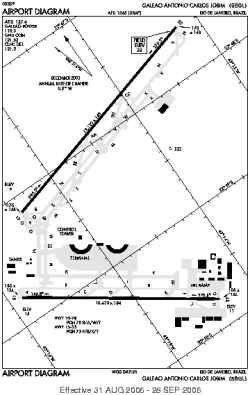
| Name: | Galeão - Antônio Carlos (Tom) Jobim International Airport |
| ICAO / IATA: | SBGL / GIG |
Details |
| Type: | Airport (Aerodrome, Airfield) |
| Use: | Public/Civil |
| Latitude: | 22°48'36"S (-22.809999) |
| Longitude: | 43°15'02"W (-43.250555) |
| Elevation: | 30 ft (9 m) |
| Runways: | 2 |
| Longest: | 13123 × 148 ft (4000 × 45 m) |
Time |
| Timezone: | UTC+31:08 (DST+33:08) |
| Local Time: | |
Weather |
| METAR: | SBGL | 041400Z 12008KT 9999 FEW020 BKN100 27/24 Q1012
|
| TAF: | SBGL | 040900Z 0412/0518 21010KT 7000 SCT017 BKN040 TX28/0415Z TN23/0508Z PROB40 0414/0418 4000 TSRA BKN015 FEW025CB TEMPO 0418/0501 17015KT 5000 RA BKN013 BECMG 0504/0506 28005KT 7000 BKN015 BECMG 0513/0515 16010KT RMK PGU
|
Related Locations |
| Nearby: | |
| Farthest: | IWO: 12124 mi / 19512 km
Iwo Jima [Iwo Jima AB], Iwo Jima Island, 13, JP |
Find: |
|
Other Information |
Maps:
|
Links:
|
Sources:
|
|