| Location |
| City: | | Thessaloniki, Kentrikí Makedonía (Central Macedonia), Greece |
| Near (Alt.): | Saloniki |
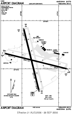
| Name: | Makedonia |
| ICAO / IATA: | LGTS / SKG |
Details |
| Type: | Airport (Aerodrome, Airfield) |
| Use: | Public/Civil |
| Latitude: | 40°31'11"N (40.519725) |
| Longitude: | 22°58'15"E (22.970950) |
| Datum: | WGS 1984 |
| Elevation: | 22 ft (7 m) |
| Runways: | 2 |
| Longest: | 8005 × 164 ft (2440 × 50 m) |
Time |
| Timezone: | UTC+2 (DST+5) |
| Local Time: | |
Weather |
| METAR: | LGTS | 041350Z 28004KT 8000 FEW010 BKN025 15/12 Q1018 NOSIG
|
| TAF: | LGTS | 041100Z 0412/0512 VRB03KT 9000 FEW010 SCT025 BECMG 0422/0424 2000 BR BKN005 BECMG 0501/0503 0500 FG OVC002 BECMG 0508/0510 9999 FEW025
|
Related Locations |
| Nearby: | |
| Farthest: | CHT: 11420 mi / 18379 km
Waitangi [Tuuta], CIT, NZ |
Find: |
|
Other Information |
Maps:
|
Sources:
|
|