| Location |
| City: | | Yuzhno-Sakhalinsk, Sakhalinskaya, Russian Federation (Russia) |
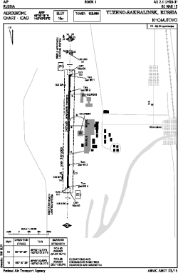
| Name: | Khomutovo Airport |
| ICAO / IATA: | UHSS / UUS |
Details |
| Type: | Airport (Aerodrome, Airfield) |
| Use: | Public/Civil |
| Latitude: | 46°53'19"N (46.888611) |
| Longitude: | 142°43'03"E (142.717500) |
| Elevation: | 59 ft (18 m) |
| Runways: | 1 |
| Longest: | 11158 × 148 ft (3401 × 45 m) |
Time |
| Timezone: | UTC+10 (DST+11) |
Weather |
| METAR: | UHSS | 041400Z 33010G15MPS 6000 BLSN SCT040CB M10/M15 Q1002 R01/450540 NOSIG RMK QFE750/1000
|
| TAF: | UHSS | 041100Z 0412/0518 33008G13MPS 1400 SHSN BLSN BKN008 BKN017CB OVC100 TEMPO 0412/0501 0700 +SHSN BLSN BKN004 BKN017CB
FM050100 29006G11MPS 9999 BKN025CB TEMPO 0501/0509 1400 SHSN BLSN BKN007 BKN025CB BECMG 0509/0511 30003MPS TEMPO 0509/0518 1400 SHSN BKN006 BKN020CB
|
Related Locations |
| Nearby: | |
| Farthest: | SAVU: 12066 mi / 19419 km
Comodoro Rivadavia [Comodoro Rivadavia UIR], AR |
Find: |
|
Other Information |
Maps:
|
Sources:
|
|