| Location |
| City: | | Kazan, Tatarstan, Russian Federation (Russia) |
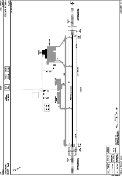
| Name: | Kazan Airport |
| ICAO / IATA: | UWKD / KZN |
Details |
| Type: | Airport (Aerodrome, Airfield) |
| Use: | Public/Civil |
| Latitude: | 55°36'25"N (55.606944) |
| Longitude: | 49°16'49"E (49.280278) |
| Elevation: | 410 ft (125 m) |
| Runways: | 1 |
| Longest: | 12303 × 148 ft (3750 × 45 m) |
Time |
| Timezone: | UTC+3 (DST+4) |
Weather |
| METAR: | UWKD | 041400Z 07006MPS 9999 OVC047 M14/M17 Q1031 R11/410045 NOSIG RMK QFE763/1018
|
| TAF: | UWKD | 041355Z 0415/0515 09006G12MPS 5000 -SN BLSN OVC015 TXM09/0515Z TNM19/0503Z TEMPO 0415/0421 07006G12MPS 2000 SN BLSN OVC005 TEMPO 0421/0503 1000 SN BLSN OVC004
FM050300 13006G12MPS 3100 -SN BLSN OVC011 TEMPO 0503/0509 0800 +SN BLSN OVC003 TEMPO 0509/0515 0800 +SNRA +FZRA OVC003
|
Related Locations |
| Nearby: | |
| Farthest: | NEMO: 11873 mi / 19108 km
Pacific Ocean [Oceanic Pole of Inaccessibility (Point Nemo)] |
Find: |
|
Other Information |
Maps:
|
Links:
|
Sources:
|
|