| Location |
| City: | | Moscow, Moskovskaya, Russian Federation (Russia) |
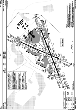
| Name: | Vnukovo International Airport |
| ICAO / IATA: | UUWW / VKO |
Details |
| Type: | Airport (Aerodrome, Airfield) |
| Use: | Public/Civil |
| Latitude: | 55°35'57"N (55.599167) |
| Longitude: | 37°16'23"E (37.273056) |
| Elevation: | 686 ft (209 m) |
| Runways: | 2 |
| Longest: | 11483 × 197 ft (3500 × 60 m) |
Time |
| Timezone: | UTC+3 (DST+4) |
Weather |
| METAR: | UUWW | 041400Z 18003MPS 140V210 0900 0800S R06/1400U FG VV001 02/02 Q1017 R06/290045 TEMPO 0300 FG RMK QBB040
|
| TAF: | UUWW | 041354Z 0415/0515 17003MPS 0800 FG OVC002 TX02/0418Z TNM02/0515Z TEMPO 0415/0420 0300 RASN FG VV001
FM042000 23005G12MPS 2000 BR OVC004 TEMPO 0420/0503 1000 SHSNRA BKN002 BKN015CB
FM050300 30005G12MPS 3100 BR BKN007 BECMG 0511/0513 21003MPS
|
Related Locations |
| Nearby: | |
| Farthest: | NEMO: 11497 mi / 18503 km
Pacific Ocean [Oceanic Pole of Inaccessibility (Point Nemo)] |
Find: |
|
Other Information |
Maps:
|
Links:
|
Sources:
|
|