| Location |
| City: | | Santa Cruz, Andrés Ibáñez, Santa Cruz, Bolivia |
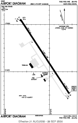
| Name: | Viru Viru International Airport |
| ICAO / IATA: | SLVR / VVI |
Details |
| Type: | Airport (Aerodrome, Airfield) |
| Use: | Public/Civil |
| Latitude: | 17°38'41"S (-17.644755) |
| Longitude: | 63°08'07"W (-63.135363) |
| Datum: | WGS 1984 |
| Elevation: | 1225 ft (373 m) |
| Runways: | 1 |
| Longest: | 11483 × 148 ft (3500 × 45 m) |
Time |
| Timezone: | UTC+30:08 (DST+32:08) |
| Local Time: | |
Weather |
| METAR: | SLVR | 041400Z 18015G26KT 9999 FEW020 SCT070 27/19 Q1018
|
| TAF: | SLVR | 040950Z 0412/0512 18015KT 9999 SCT020 FEW027TCU TX33/0419Z TN22/0510Z BECMG 0423/0501 15005KT NSC
|
Related Locations |
| Nearby: | |
| Farthest: | DSX: 12219 mi / 19665 km
Pratas Island [Dongsha Airport], TW |
Find: |
|
Other Information |
Maps:
|
Sources:
|
|