| Location |
| City: | | Ipswich, Queensland, Australia |
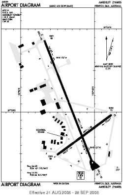
| Name: | RAAF Amberley |
| ICAO: | YAMB |
Details |
| Type: | Airport (Aerodrome, Airfield) |
| Use: | Military |
| Latitude: | 27°38'26"S (-27.640555) |
| Longitude: | 152°42'43"E (152.711944) |
| Datum: | WGS 1984 |
| Elevation: | 91 ft (28 m) |
| Runways: | 2 |
| Longest: | 9997 × 148 ft (3047 × 45 m) |
Time |
| Timezone: | UTC+10 (DST+12) |
| Local Time: | |
Weather |
| METAR: | YAMB | 041400Z AUTO 14006KT 9999 // NCD 22/19 Q1012
|
| TAF: | YAMB | 040508Z 0406/0424 07015KT 9999 FEW040 SCT060
FM041000 10007KT 9999 FEW020 SCT035
FM041600 12008KT 9999 -SHRA SCT020 BKN030 INTER 0418/0424 4000 SHRA SCT015 BKN020
|
Related Locations |
| Nearby: | |
| Farthest: | VDE: 11870 mi / 19103 km
Valverde [El Hierro], El Hierro Island, CN, ES |
Find: |
|
Other Information |
Maps:
|
Sources:
|
|