| Location |
| City: | | Kingston, Ontario, Canada |
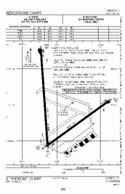
| Name: | Norman Rogers Airport |
| ICAO / IATA: | CYGK / YGK |
Details |
| Type: | Airport (Airfield) |
| Use: | Public/Civil |
| Latitude: | 44°13'33"N (44.225833) |
| Longitude: | 76°35'48"W (-76.596666) |
| Elevation: | 303 ft (92 m) |
| Runways: | 2 |
| Longest: | 4929 ft (1502 m) |
Time |
| Timezone: | UTC+29:08 (DST+32:08) |
| Local Time: | |
Weather |
| METAR: | CYGK | 041400Z 18004KT 5SM BR BKN008 OVC022 02/02 A2996 RMK SF6SC2 SLP150
|
| TAF: | CYGK | 041240Z 0413/0501 21010KT P6SM OVC015 TEMPO 0413/0417 2SM -DZ BR OVC007
FM041700 18015KT P6SM SCT010 OVC030 TEMPO 0417/0420 BKN010 OVC030
FM042000 15015KT P6SM BKN040
FM042300 18010KT P6SM SCT050 RMK NXT FCST BY 042000Z
|
Related Locations |
| Nearby: | |
| Farthest: | YAUG: 11508 mi / 18521 km
Augusta [Augusta Airport], WA, AU |
Find: |
|
Other Information |
Maps:
|
Links:
|
Sources:
|
|