| Location |
| City: | | Kelowna, British Columbia, Canada |
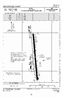
| Name: | Kelowna International Airport |
| ICAO / IATA: | CYLW / YLW |
Details |
| Type: | Airport (Airfield) |
| Use: | Public/Civil |
| Latitude: | 49°57'26"N (49.957222) |
| Longitude: | 119°22'40"W (-119.377777) |
| Elevation: | 1420 ft (433 m) |
| Runways: | 1 |
| Longest: | 8900 ft (2713 m) |
Time |
| Timezone: | UTC+26:08 (DST+29:08) |
| Local Time: | |
Weather |
| METAR: | CYLW | 041400Z AUTO 33015G20KT 9SM -SN OVC065 M15/M21 A2995 RMK SLP181
|
| TAF: | CYLW | 041238Z 0413/0501 34015KT P6SM OVC050 TEMPO 0413/0423 5SM -SN OVC030
FM042300 34010KT P6SM SCT050 RMK FCST BASED ON AUTO OBS. NXT FCST BY 041900Z
|
Related Locations |
| Nearby: | |
| Farthest: | FAME: 11374 mi / 18305 km
Marion Island, Prince Edward Islands, WC, ZA |
Find: |
|
Other Information |
Maps:
|
Links:
|
Sources:
|
|