| Location |
| City: | | Portage la Prairie, Manitoba, Canada |
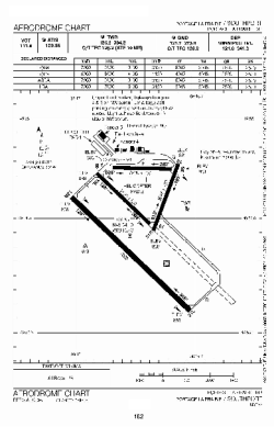
| Name: | Southport Airport |
| ICAO / IATA: | CYPG / YPG |
Details |
| Type: | Airport (Airfield) |
| Use: | Public/Civil |
| Latitude: | 49°54'11"N (49.903056) |
| Longitude: | 98°16'26"W (-98.273888) |
| Elevation: | 884 ft (269 m) |
| Runways: | 4 |
| Longest: | 6997 ft (2133 m) |
Time |
| Timezone: | UTC+28:08 (DST+31:08) |
| Local Time: | |
Weather |
| METAR: | CYPG | 041400Z 35018G23KT 1SM -SN BLSN OVC008 M24/M27 A3020 RMK BLSN3SF5 VIS VRB 1/2-1 1/2 SLP260
|
| TAF: | CYPG | 041315Z 0413/0501 34018G28KT 11/2SM -SN BLSN OVC008 TEMPO 0413/0416 2SM -SN OVC010
FM041600 34018G28KT 2SM -SN BLSN BKN012 OVC025 TEMPO 0416/0419 6SM -SN SCT012 OVC025
FM041900 34015G25KT P6SM SCT012 OVC100 BECMG 0422/0424 34012KT RMK NXT FCST BY 041800Z
|
Related Locations |
| Nearby: | |
| Farthest: | YCSK: 10905 mi / 17550 km
Casey Station [Casey Station Skiway], Wilkes Land, AQ |
Find: |
|
Other Information |
Maps:
|
Sources:
|
|