| Location |
| City: | | Roberval, Québec, Canada |
| Name: | Roberval Airport |
| ICAO / IATA: | CYRJ / YRJ |
Details |
| Type: | Airport (Airfield) |
| Use: | Public/Civil |
| Latitude: | 48°31'12"N (48.520000) |
| Longitude: | 72°15'57"W (-72.265832) |
| Elevation: | 586 ft (179 m) |
| Runways: | 1 |
| Longest: | 5000 ft (1524 m) |
Time |
| Timezone: | UTC+29:08 (DST+32:08) |
| Local Time: | |
Weather |
| METAR: | CYRJ | 041400Z 30006KT 20SM FEW025 OVC120 M13/M16 A2998 RMK SC2AC6 SLP172
|
| TAF: | CYRJ | 041240Z 0413/0501 VRB03KT P6SM SCT020 OVC040 TEMPO 0413/0424 OVC020
FM050000 VRB03KT P6SM -SN SCT020 OVC080 RMK NXT FCST BY 042000Z
|
Related Locations |
| Nearby: | |
| Farthest: | YAUG: 11380 mi / 18315 km
Augusta [Augusta Airport], WA, AU |
Find: |
|
Other Information |
Maps:
|
Sources:
|
|
|
|
Airport Diagram
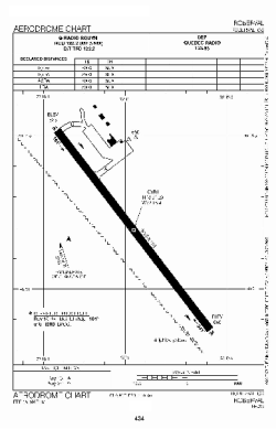
Airport diagram PDF from NAV Canada
|
