| Location |
| City: | | Toronto, Ontario, Canada |
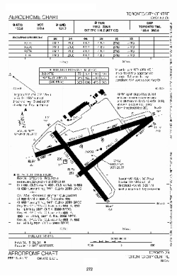
| Name: | Billy Bishop Toronto City Airport (Toronto City Centre Airport) |
| ICAO / IATA: | CYTZ / YTZ |
Details |
| Type: | Airport (Airfield) |
| Use: | Public/Civil |
| Latitude: | 43°37'39"N (43.627500) |
| Longitude: | 79°23'46"W (-79.396110) |
| Elevation: | 252 ft (77 m) |
| Runways: | 3 |
| Longest: | 3988 ft (1216 m) |
Time |
| Timezone: | UTC+29:08 (DST+32:08) |
| Local Time: | |
Weather |
| METAR: | CYTZ | 041400Z AUTO 27002KT 9SM FEW055 OVC088 05/03 A2993 RMK SLP138
|
| TAF: | CYTZ | 041338Z 0414/0514 26005KT P6SM BKN060 TEMPO 0414/0417 BKN020
FM041700 21012KT P6SM SCT020 BKN240 TEMPO 0417/0420 BKN020
FM042300 21015KT P6SM -RA SCT020 OVC030
FM050100 21015KT 21/2SM -DZ -RA BR SCT005 OVC010
FM050500 24012KT 6SM BR FEW005 OVC010 PROB30 0505/0507 1SM -DZ BR OVC005
FM050700 27010KT P6SM BKN010
FM051300 29012KT P6SM SCT025 RMK FCST BASED ON AUTO OBS. NXT FCST BY 042000Z
|
Related Locations |
| Nearby: | |
| Farthest: | YAUG: 11427 mi / 18390 km
Augusta [Augusta Airport], WA, AU |
Find: |
|
Other Information |
Maps:
|
Links:
|
Sources:
|
|