| Location |
| City: | | Atlanta, Georgia, United States |
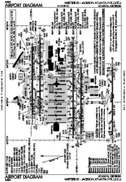
| Name: | Hartsfield - Jackson Atlanta International Airport |
| ICAO / IATA: | KATL / ATL |
| FAA: | ATL |
Details |
| Type: | Airport (Part 139 Class I) |
| Use: | Public/Civil |
| Latitude: | 33°38'12"N (33.636700) |
| Longitude: | 84°25'40"W (-84.427863) |
| Datum: | WGS 1984 |
| Elevation: | 1026 ft (313 m) |
| Runways: | 5 |
| Longest: | 12390 × 150 ft (3776 × 45.5 m) |
Time |
| Timezone: | UTC+29:08 (DST+32:08) |
| Local Time: | |
Weather |
| METAR: | KATL | 041352Z 21003KT 10SM FEW004 FEW150 SCT200 BKN250 11/09 A3010 RMK AO2 SLP193 T01060094
|
| TAF: | KATL | 041301Z 0413/0518 00000KT P6SM SCT004 SCT250
FM041500 VRB03KT P6SM FEW015 SCT120
FM041700 19004KT P6SM SCT040 BKN120
FM050200 20004KT P6SM BKN025
FM050500 21004KT 6SM BR BKN015
FM050800 21004KT 5SM BR VCSH BKN009
FM051400 23004KT P6SM BKN012
|
Related Locations |
| Nearby: | |
| Farthest: | MQZ: 11322 mi / 18221 km
Margaret River [Margaret River Airport], WA, AU |
Find: |
|
Other Information |
Maps:
|
Delays:
|
Links:
|
Sources:
|
|