| Location |
| City: | | Nashville, Tennessee, United States |
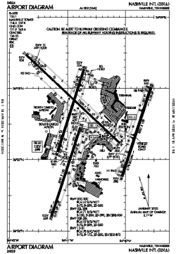
| Name: | Nashville International Airport |
| ICAO / IATA: | KBNA / BNA |
| FAA: | BNA |
Details |
| Type: | Airport (Part 139 Class I) |
| Use: | Public/Civil |
| Latitude: | 36°07'28"N (36.124475) |
| Longitude: | 86°40'41"W (-86.678180) |
| Datum: | WGS 1984 |
| Elevation: | 599 ft (183 m) |
| Runways: | 4 |
| Longest: | 11030 × 150 ft (3362 × 45.5 m) |
Time |
| Timezone: | UTC+28:08 (DST+31:08) |
| Local Time: | |
Weather |
| METAR: | KBNA | 041353Z 16008KT 10SM FEW015 BKN028 OVC100 13/10 A2999 RMK AO2 SLP153 T01330100
|
| TAF: | KBNA | 041338Z 0414/0512 16006KT P6SM OVC025
FM041500 18010KT P6SM VCSH SCT008 OVC015 TEMPO 0415/0418 4SM -SHRA
FM050000 19006KT P6SM OVC015
|
Related Locations |
| Nearby: | |
| Farthest: | YAUG: 11205 mi / 18032 km
Augusta [Augusta Airport], WA, AU |
Find: |
|
Other Information |
Maps:
|
Delays:
|
Links:
|
Sources:
|
|