| Location |
| City: | | Burbank, California, United States |
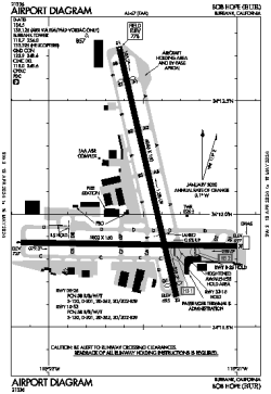
| Name: | Hollywood Burbank Airport (Bob Hope Airport) |
| ICAO / IATA: | KBUR / BUR |
| FAA: | BUR |
Details |
| Type: | Airport (Part 139 Class I) |
| Use: | Public/Civil |
| Latitude: | 34°12'02"N (34.200694) |
| Longitude: | 118°21'31"W (-118.358666) |
| Datum: | WGS 1984 |
| Elevation: | 778 ft (237 m) |
| Runways: | 2 |
| Longest: | 6886 × 150 ft (2099 × 45.5 m) |
Time |
| Timezone: | UTC+26:08 (DST+29:08) |
| Local Time: | |
Weather |
| METAR: | KBUR | 041418Z 13008KT 6SM BR BKN014 BKN020 OVC028 11/09 A2982 RMK AO2 RAE08 P0000 T01060094 $
|
| TAF: | KBUR | 041146Z 0412/0512 14007KT 6SM -SHRA BKN015 OVC025
FM041500 15017G25KT 6SM -SHRA SCT015 OVC035
FM041800 16017G25KT 4SM RA BR OVC012
FM042200 21012KT 5SM -RA BR SCT012 OVC020
FM050300 19012KT P6SM -SHRA BKN020 OVC030
FM050700 15010KT P6SM -SHRA SCT020 OVC030
|
Related Locations |
| Nearby: | |
| Farthest: | ZSE: 11468 mi / 18456 km
St-Pierre (St-Pierre de la Réunion) [Pierrefonds], RE |
Find: |
|
Other Information |
Maps:
|
Delays:
|
Links:
|
Sources:
|
|