| Location |
| City: | | Akron, Ohio, United States |
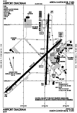
| Name: | Akron-Canton Regional |
| ICAO / IATA: | KCAK / CAK |
| FAA: | CAK |
Details |
| Type: | Airport (Part 139 Class I) |
| Use: | Public/Civil |
| Latitude: | 40°54'54"N (40.915056) |
| Longitude: | 81°26'37"W (-81.443638) |
| Datum: | WGS 1984 |
| Elevation: | 1225 ft (373 m) |
| Runways: | 2 |
| Longest: | 8204 × 150 ft (2501 × 45.5 m) |
Time |
| Timezone: | UTC+29:08 (DST+32:08) |
| Local Time: | |
Weather |
| METAR: | KCAK | 041351Z 16007KT 10SM SCT250 06/02 A2998 RMK AO2 SLP156 T00610017
|
| TAF: | KCAK | 041124Z 0412/0512 19008KT P6SM FEW080 SCT250
FM042200 19010G20KT P6SM OVC040
FM042300 19010G20KT 4SM -SHRA BR OVC035
FM050300 22010G20KT 1 1/2SM -SHRA BR OVC008
FM050600 22010KT P6SM OVC008
FM050900 27010KT P6SM OVC008
|
Related Locations |
| Nearby: | |
| Farthest: | YAUG: 11425 mi / 18387 km
Augusta [Augusta Airport], WA, AU |
Find: |
|
Other Information |
Maps:
|
Delays:
|
Links:
|
Sources:
|
|