| Location |
| City: | | Constanta, Constanta, Romania |
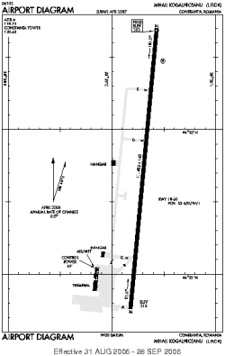
| Name: | Mihail Kogainiceanu International Airport |
| ICAO / IATA: | LRCK / CND |
Details |
| Type: | Airport (Aerodrome, Airfield) |
| Use: | Public/Civil, Military |
| Latitude: | 44°21'44"N (44.362222) |
| Longitude: | 28°29'18"E (28.488333) |
| Datum: | WGS 1984 |
| Elevation: | 353 ft (108 m) |
| Runways: | 1 |
| Longest: | 11483 × 148 ft (3500 × 45 m) |
Time |
| Timezone: | UTC+2 (DST+5) |
| Local Time: | |
Weather |
| METAR: | LRCK | 041400Z 07007KT CAVOK 13/10 Q1021 NOSIG
|
| TAF: | LRCK | 041100Z 0412/0512 28005KT CAVOK BECMG 0414/0416 5000 BR BECMG 0416/0418 1500 BR BKN005 BECMG 0418/0420 0600 FG BKN002 TEMPO 0421/0504 0150 FG VV001 BECMG 0505/0507 04010KT 1500 BR BKN005 BECMG 0507/0509 5000 BKN015 TEMPO 0509/0512 7000 NSW SCT020
|
Related Locations |
| Nearby: | |
| Farthest: | CHT: 11203 mi / 18030 km
Waitangi [Tuuta], CIT, NZ |
Find: |
|
Other Information |
Maps:
|
Links:
|
Sources:
|
|