| Location |
| City: | | Crestview, Florida, United States |
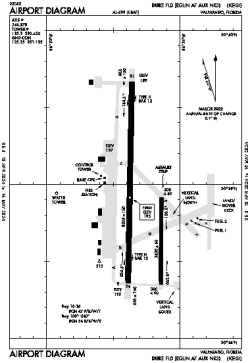
| Name: | Duke Field (Eglin AF Auxiliary Number 3) |
| ICAO / IATA: | KEGI / EGI |
| FAA: | EGI |
Details |
| Type: | Airport (Airfield) |
| Use: | Military |
| Latitude: | 30°38'55"N (30.648587) |
| Longitude: | 86°31'19"W (-86.521958) |
| Datum: | WGS 1984 |
| Elevation: | 195 ft (59 m) |
| Runways: | 2 |
| Longest: | 8025 × 150 ft (2446 × 45.5 m) |
Time |
| Timezone: | UTC+28:08 (DST+31:08) |
| Local Time: | |
Weather |
| METAR: | KEGI | 041356Z AUTO 00000KT 10SM FEW200 13/13 A3007 RMK AO2 SLP184 T01280128 $
|
| TAF: | KEGI | 041000Z 0410/0516 10003KT 9999 OVC008 QNH3001INS BECMG 0412/0413 11005KT 9999 BKN008 QNH3003INS BECMG 0416/0417 12007KT 9999 SCT010 BKN030 QNH3006INS BECMG 0422/0423 13007KT 9999 BKN010 OVC030 QNH3004INS BECMG 0501/0502 14005KT 9999 OVC007 QNH3005INS BECMG 0504/0505 14005KT 4800 BR OVC007 QNH3005INS BECMG 0514/0515 17007KT 9999 NSW BKN007 OVC030 QNH3008INS TX20/0421Z TN13/0412Z
|
Related Locations |
| Nearby: | |
| Farthest: | USL: 11195 mi / 18017 km
Useless Loop, WA, AU |
Find: |
|
Other Information |
Maps:
|
Links:
|
Sources:
|
|