| Location |
| City: | | Bergen, Norway |
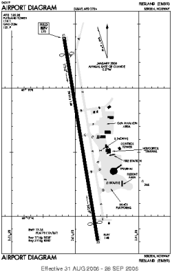
| Name: | Flesland |
| ICAO / IATA: | ENBR / BGO |
Details |
| Type: | Airport (Aerodrome, Airfield) |
| Use: | Public/Civil |
| Latitude: | 60°17'36"N (60.293386) |
| Longitude: | 5°13'05"E (5.218142) |
| Datum: | WGS 1984 |
| Elevation: | 170 ft (52 m) |
| Runways: | 1 |
| Longest: | 9810 × 148 ft (2990 × 45 m) |
Time |
| Timezone: | UTC+1 (DST+4) |
| Local Time: | |
Weather |
| METAR: | ENBR | 041420Z 12004KT 090V170 9999 VCSH FEW015 BKN025 03/00 Q1003 TEMPO 4000 RADZ BR BKN012 RMK WIND 1200FT 11016KT
|
| TAF: | ENBR | 041100Z 0412/0512 12005KT 9999 -RA FEW010 BKN020 TEMPO 0412/0424 3000 RADZ BR BKN012 PROB40 TEMPO 0500/0505 BKN005
|
Related Locations |
| Nearby: | |
| Farthest: | NZTB: 11301 mi / 18188 km
Terra Nova Bay [Mario Zucchelli Station], AQ |
Find: |
|
Other Information |
Maps:
|
Sources:
|
|