| Location |
| City: | | Huntsville, Alabama, United States |
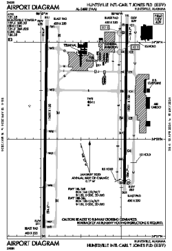
| Name: | Huntsville International-Carl T Jones Field |
| ICAO / IATA: | KHSV / HSV |
| FAA: | HSV |
Details |
| Type: | Airport (Part 139 Class I) |
| Use: | Public/Civil |
| Latitude: | 34°38'14"N (34.637197) |
| Longitude: | 86°46'30"W (-86.775053) |
| Datum: | WGS 1984 |
| Elevation: | 628 ft (191 m) |
| Runways: | 2 |
| Longest: | 12600 × 150 ft (3840 × 45.5 m) |
Time |
| Timezone: | UTC+28:08 (DST+31:08) |
| Local Time: | |
Weather |
| METAR: | KHSV | 041353Z 17005KT 10SM -RA OVC012 13/12 A3005 RMK AO2 RAB1258 SLP172 P0000 T01280117
|
| TAF: | KHSV | 041126Z 0412/0512 16008KT P6SM SCT015 OVC040
FM041500 18009KT P6SM -RA BKN007 OVC015
FM041900 16008KT P6SM OVC015
FM050200 17005KT 4SM BR VCSH BKN007 OVC015
|
Related Locations |
| Nearby: | |
| Farthest: | YAUG: 11194 mi / 18016 km
Augusta [Augusta Airport], WA, AU |
Find: |
|
Other Information |
Maps:
|
Delays:
|
Links:
|
Sources:
|
|