| Location |
| City: | | Hilo, Hawaii, Hawaii, United States |
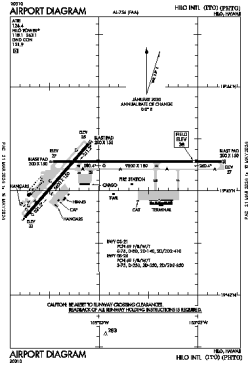
| Name: | Hilo International Airport |
| ICAO / IATA: | PHTO / ITO |
| FAA: | ITO |
Details |
| Type: | Airport (Part 139 Class I) |
| Use: | Public/Civil |
| Latitude: | 19°43'13"N (19.720263) |
| Longitude: | 155°02'54"W (-155.048469) |
| Datum: | WGS 1984 |
| Elevation: | 37 ft (11 m) |
| Runways: | 2 |
| Longest: | 9800 × 150 ft (2987 × 45.5 m) |
Time |
| Timezone: | UTC+24:08 (DST+26:08) |
| Local Time: | |
Weather |
| METAR: | PHTO | 041403Z AUTO 36011KT 10SM SCT028 OVC036 21/18 A2991 RMK AO2 T02060183 TSNO
|
| TAF: | PHTO | 041307Z 0413/0512 22005KT P6SM VCSH SCT025 BKN035 TEMPO 0413/0417 VRB06KT 5SM SHRA BR SCT015 BKN020 BKN030
FM042000 01011KT P6SM VCSH SCT025 BKN040
FM050500 VRB05KT P6SM VCSH SCT025 BKN040
|
Related Locations |
| Nearby: | |
| Farthest: | FBMM: 12362 mi / 19895 km
Makalamabedi [Makalamabedi Airport], NW, BW |
Find: |
|
Other Information |
Maps:
|
Links:
|
Sources:
|
|