| Location |
| City: | | Fort Knox, Kentucky, United States |
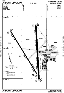
| Name: | Godman AAF Airport |
| ICAO / IATA: | KFTK / FTK |
| FAA: | FTK |
Details |
| Type: | Airport (Airfield) |
| Use: | Military |
| Latitude: | 37°54'25"N (37.907065) |
| Longitude: | 85°58'19"W (-85.972035) |
| Datum: | WGS 1984 |
| Elevation: | 754 ft (230 m) |
| Runways: | 2 |
| Longest: | 5184 × 150 ft (1580 × 45.5 m) |
Time |
| Timezone: | UTC+29:08 (DST+32:08) |
| Local Time: | |
Weather |
| METAR: | KFTK | 041356Z AUTO 18011KT 10SM CLR 12/09 A2994 RMK AO2 SLP141 T01170094 $
|
| TAF: | KFTK | 040900Z 0409/0515 18009KT 8000 BR SCT007 OVC015 QNH2992INS BECMG 0414/0415 18012G18KT 6000 -SHRA BR OVC005 QNH2986INS TEMPO 0415/0421 20015G25KT BECMG 0420/0421 21009KT 6000 BR OVC005 QNH2989INS TX13/0420Z TN09/0409Z
|
Related Locations |
| Nearby: | |
| Farthest: | YAUG: 11238 mi / 18086 km
Augusta [Augusta Airport], WA, AU |
Find: |
|
Other Information |
Maps:
|
Links:
|
Sources:
|
|