| Location |
| City: | | Greenwood, Mississippi, United States |
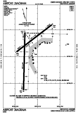
| Name: | Greenwood-Leflore Airport |
| ICAO / IATA: | KGWO / GWO |
| FAA: | GWO |
Details |
| Type: | Airport (Airfield) |
| Use: | Public/Civil |
| Latitude: | 33°29'36"N (33.493309) |
| Longitude: | 90°05'12"W (-90.086676) |
| Datum: | WGS 1984 |
| Elevation: | 162 ft (49 m) |
| Runways: | 2 |
| Longest: | 6501 × 150 ft (1982 × 45.5 m) |
Time |
| Timezone: | UTC+28:08 (DST+31:08) |
| Local Time: | |
Weather |
| METAR: | KGWO | 041353Z AUTO 18009KT 10SM OVC017 16/13 A2996 RMK AO2 SLP146 T01560133 $
|
| TAF: | KGWO | 041120Z 0412/0512 18008KT P6SM VCSH BKN025 OVC050
FM041300 18009KT P6SM BKN015 OVC040
FM042100 19010KT P6SM BKN025 OVC050
FM050300 19004KT 6SM BR BKN015 BKN025
FM050700 18004KT 5SM BR BKN006 OVC030
|
Related Locations |
| Nearby: | |
| Farthest: | MQZ: 10997 mi / 17698 km
Margaret River [Margaret River Airport], WA, AU |
Find: |
|
Other Information |
Maps:
|
Links:
|
Sources:
|
|