| Location |
| City: | | Jackson, Michigan, United States |
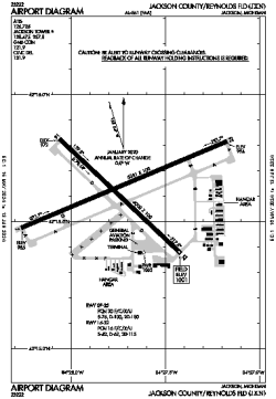
| Name: | Jackson County/Reynolds Field |
| ICAO / IATA: | KJXN / JXN |
| FAA: | JXN |
Details |
| Type: | Airport (Airfield) |
| Use: | Public/Civil |
| Latitude: | 42°15'38"N (42.260443) |
| Longitude: | 84°27'44"W (-84.462138) |
| Datum: | WGS 1984 |
| Elevation: | 1000 ft (305 m) |
| Runways: | 2 |
| Longest: | 5351 × 100 ft (1631 × 30.5 m) |
Time |
| Timezone: | UTC+29:08 (DST+32:08) |
| Local Time: | |
Weather |
| METAR: | KJXN | 041356Z 16009KT 10SM FEW055 SCT075 BKN100 09/06 A2981 RMK AO2 SLP097 T00890061
|
| TAF: | KJXN | 041136Z 0412/0512 19008KT P6SM BKN035 WS020/24035KT
FM041500 18010G16KT P6SM BKN025 WS020/23035KT
FM041700 20012G20KT 4SM -SHRA BR OVC004 WS020/22045KT
FM042300 22010G16KT 3SM -RA BR OVC003
FM050200 25010KT 6SM BR OVC007
FM050800 30013G21KT P6SM BKN010
|
Related Locations |
| Nearby: | |
| Farthest: | YAUG: 11245 mi / 18098 km
Augusta [Augusta Airport], WA, AU |
Find: |
|
Other Information |
Maps:
|
Delays:
|
Links:
|
Sources:
|
|