| Location |
| City: | | Logan, Utah, United States |
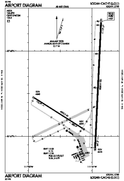
| Name: | Logan-Cache Airport |
| ICAO / IATA: | KLGU / LGU |
| FAA: | LGU |
Details |
| Type: | Airport (Part 139 Class IV) |
| Use: | Public/Civil |
| Latitude: | 41°47'30"N (41.791771) |
| Longitude: | 111°51'06"W (-111.851646) |
| Datum: | WGS 1984 |
| Elevation: | 4456 ft (1358 m) |
| Runways: | 2 |
| Longest: | 9020 × 100 ft (2749 × 30.5 m) |
Time |
| Timezone: | UTC+27:08 (DST+30:08) |
| Local Time: | |
Weather |
| METAR: | KLGU | 041351Z AUTO 17022G27KT 10SM -RA SCT050 BKN070 OVC095 04/M01 A2953 RMK AO2 PK WND 16027/1351 SLP994 P0001 T00441011
|
| TAF: | KLGU | 041146Z 0412/0512 17015G22KT P6SM BKN060 OVC100
FM041400 15010G18KT P6SM -SHRA OVC040
FM042000 20011KT P6SM VCSH BKN025 OVC040
FM042300 18010KT 3SM -SN BR BKN015 OVC025
FM050700 18010KT P6SM VCSH BKN025 BKN040
|
Related Locations |
| Nearby: | |
| Farthest: | FAME: 10908 mi / 17555 km
Marion Island, Prince Edward Islands, WC, ZA |
Find: |
|
Other Information |
Maps:
|
Links:
|
Sources:
|
|