| Location |
| City: | | Norfolk, Nebraska, United States |
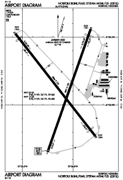
| Name: | Norfolk Regional/Karl Stefan Memorial Field |
| ICAO / IATA: | KOFK / OFK |
| FAA: | OFK |
Details |
| Type: | Airport (Airfield) |
| Use: | Public/Civil |
| Latitude: | 41°59'08"N (41.985460) |
| Longitude: | 97°26'06"W (-97.435113) |
| Datum: | WGS 1984 |
| Elevation: | 1572 ft (479 m) |
| Runways: | 2 |
| Longest: | 5806 × 100 ft (1770 × 30.5 m) |
Time |
| Timezone: | UTC+28:08 (DST+31:08) |
| Local Time: | |
Weather |
| METAR: | KOFK | 041356Z AUTO 32018G32KT 10SM CLR M16/M21 A2997 RMK AO2 PK WND 35037/1258 SLP178 T11611206
|
| TAF: | KOFK | 041120Z 0412/0512 33020G30KT P6SM BKN020 TEMPO 0412/0413 6SM -SN
FM041300 33021G28KT P6SM SKC
FM042100 36012KT P6SM SCT100
FM050000 35010KT P6SM SCT250
|
Related Locations |
| Nearby: | |
| Farthest: | YAUG: 10602 mi / 17062 km
Augusta [Augusta Airport], WA, AU |
Find: |
|
Other Information |
Maps:
|
Links:
|
Sources:
|
|